The One Weird Trick Behind Map Datums!

Back in 2005, when Google Earth and Google Maps were launched, the public had their first taste of easily accessible satellite photography. However, two aspects went unnoticed by most users…

The first was that much of the clear and colorful imagery was not from satellites way, way out there in spaaaace - but was actually much closer, from high-flying aircraft!

Not a real satellite

While most of us were oohing and aahing over the magic of satellite (and aircraft!) imagery, we missed something else magical – that we could view our rather round planet on our very flat and square screens?

We take it for granted that maps are printed on flat paper, but when civil engineers tried using Google Earth as a background for their designs..? Well, they discovered it wasn’t so simple!

Even for quite small projects you will find it you line up one part of a satellite image with your drawing, other bits will just not line up, at all.

Because the Earth is not flat!

Around the world and throughout history this has been a problem, leading to the creation of over 3000 different map datums, projections or coordinate systems, to try to cope with this.

Map Datum or Projection, what’s the difference?

A datum is about accurately positioning a model of the Earth to match it with reality, essentially determining where and how the model sits relative to the actual Earth.

A projection is about transforming that three-dimensional reality into a useful two-dimensional depiction, deciding how best to flatten a globe onto a page or screen with the least distortion for their purpose.

Their purpose?

Yes, you see many attempts have been made to create flat maps of a round planet, such as showing it as though inside a cylinder, or as a round map based on a central point, or as a cone, or…

The thing is, it’s not really possible to lay a curved surface flat, so something has to give!

Each projection preserves some properties (e.g., area, shape, direction, or distance) while distorting others.

Hence the choice of map projection depends on the purpose of the map and the area being represented. For example, the Mercator projection is often used for navigation because it preserves direction, but it distorts the size of countries near the poles.

In contrast the Gall-Peters projection is used to compare the relative sizes of countries because it preserves area, but then it distorts shape, direction, and distance!

All of those complicated systems strive to do the same thing that Plex-Earth does simply and automatically for engineers who want to design with aerial imagery as a background, or reference.

Plex-Earth’s ‘one weird trick’ is as simple as peeling an orange…

Yes, the secret is to slice it up into smaller segments; the smaller the better!

Lambros Kaliakatsos, our Founder and CEO, explains that: “It’s a bit like peeling an orange and trying to lay the peel flat – not so easy, right? But (if) we cut the peel into smaller, manageable pieces, they lay flat perfectly.”

Not a real orange…

But Wait, There’s More!

But even that one weird trick isn’t enough - because the segments move!

While not a datum per se, the ITRF (International Terrestrial Reference Frame) provides the most precise global reference frame for Earth science applications, including the study of sea level changes, satellite orbit tracking and yes, watching the tectonic plates moving…

That’s why some datums are anchored not by Earth’s coordinates but to the biggest and nearest tectonic plate. So if the plate moves, the map datum moves with it!

For example while WGS 84 (World Geodetic System 1984) is used by Google Earth and is great for positioning or world navigation, the main datum for the USA is actually NAD 83 (North American Datum 1983). This is fixed to the North American tectonic plate, making it more stable for regional use compared to WGS 84.

How about for Europe? ETRS89 (European Terrestrial Reference System 1989) is tied to the European plate…

Is this starting to sound (even more) complicated?

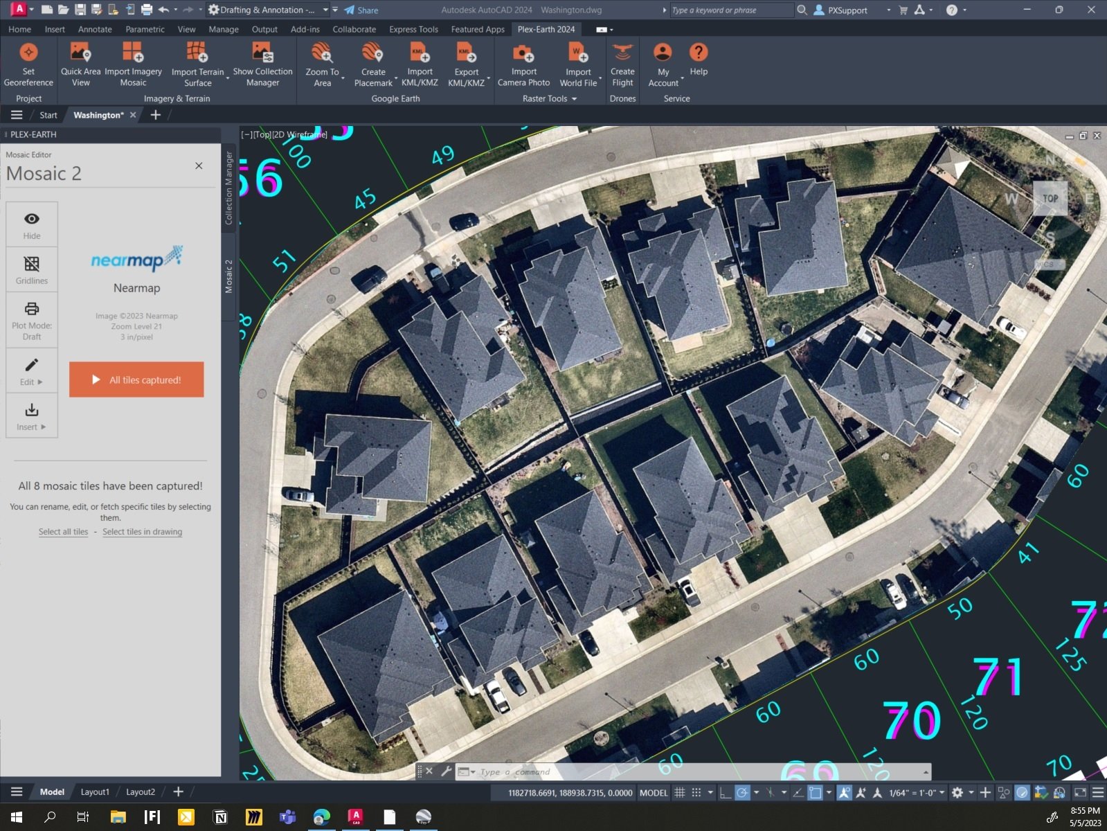
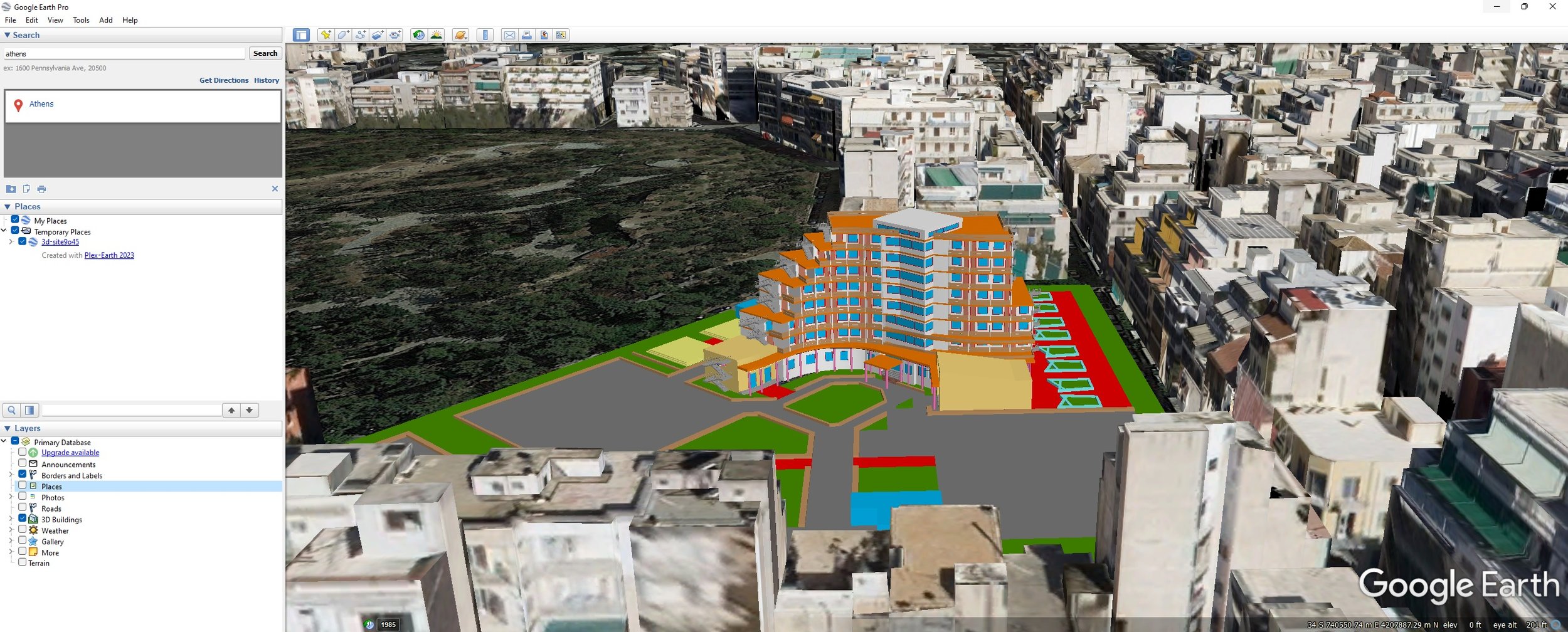
Well here’s the weirdest and easiest trick of all; you can just select a specific known spot of your project on Google Earth. Easy, right?

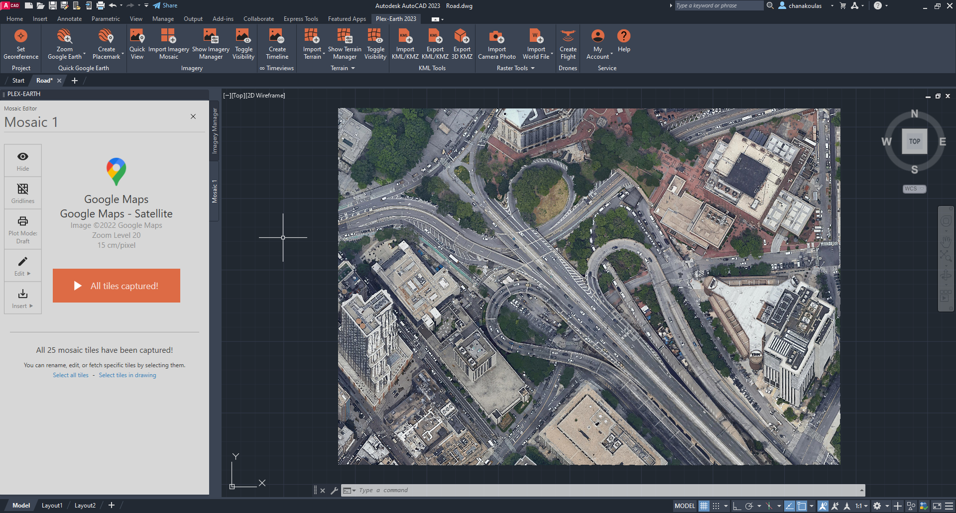
From there you can just let Plex-Earth import, scale and perfectly align our free or premium, updated and higher-res’ satellite and aerial imagery for you, automagically!

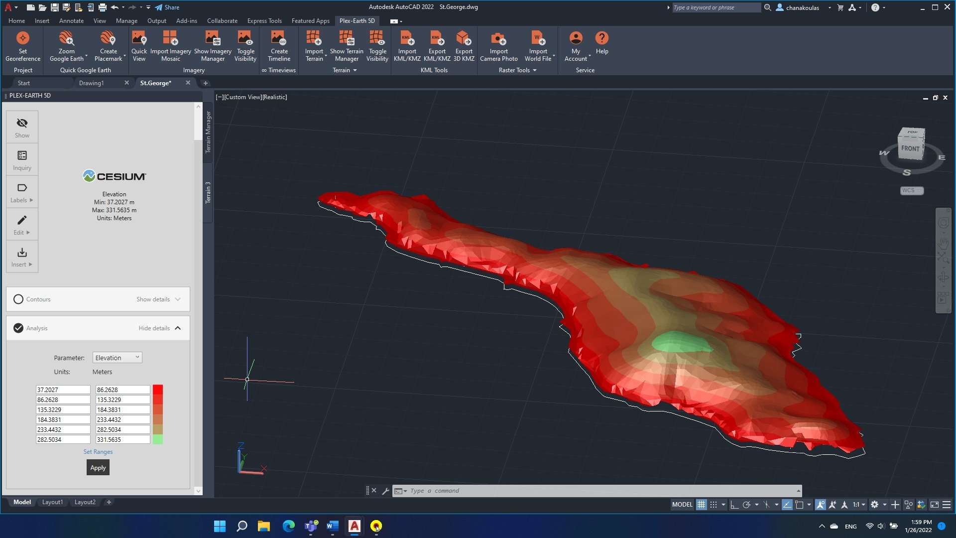
There’s even more - it provides terrain data as well!

Try Plex-Earth today with a free trial, then  play with the super-easy custom geo-referencing feature to discover just how weirdly easy it all becomes, when you’re using Plex-Earth!

Formidable! Plex-Earth Meets Forma and more, at AU23…

Autodesk University 2023 wasn't just the biggest event in the AEC world – it was a groundbreaking showcase of the AEC future - and Plex-Earth is right at the heart of it!

But first, a hat-tip to Nick…

Nick’s Class was a Sold-Out Success Story – Twice!

Nick Chanakoulas, our Head of Customer Success, started AU23 with his own impressive success, leading a live class that was a total hit by selling out before the conference even started!

The demand was so high that Autodesk set up a rare second session, which, unsurprisingly, also sold out!

Nick’s classes have a well-deserved reputation from previous AUs, so we were hopeful for it to be popular again this year, but we weren’t expecting a packed, 150+ crowd, with some willing to stand at the back without seats!

And check out that ceiling!

This year he was introducing the Geospatially-informed Design framework, created right here by the Plex-Earth team (more about that in a minute…)

That he packed every chair, twice, is a testament to the growing interest in integrating real-world data into project planning, a field where Plex-Earth has always excelled, but above all it’s a tribute to Nick himself. Well done Nick!

The Future of Autodesk’s Ecosystem – Forma

Autodesk's CEO, Andrew Anagnost, kicked off the event by spotlighting Autodesk Forma, the latest addition to the Autodesk family, and arguably the new heart of it.

Forma, a cloud-based AI and generative design tool, is set to revolutionize the future of AEC, and those are not idle words!

It truly is a futuristic platform, based on Spacemaker, which Autodesk acquired in 2020 for $240 million. Forma stands alongside Fusion (for manufacturing) and Flow (for entertainment), creating a triad that represents Autodesk's future vision.

It's primarily designed for use at the early - and thus critical - stages of AEC construction, and complements, not replaces, tools like AutoCAD and Revit.

As Nicolas Mangon, vice president of AEC strategy at Autodesk said in an interview with ENR regarding where Forma will sit in the Autodesk line-up:

"This is not a replacement of Revit, it's a different way of working. Some will still use AutoCAD, others will use Revit, some will use … Forma. Forma is designed to be used at the planning phase of building."

Seeing the bigger picture, then zooming in on the details of early planning is where Plex-Earth has always excelled. Now we're bringing our geospatial expertise right into the heart of this exciting new platform!

Yes, drumroll please…

Plex-Earth is now one of the first 3rd-party extensions ever accepted for Autodesk Forma!

Captured is the moment we were informed Plex-Earth is officially published as a Forma extension!

Pictured above are Andrew Kinaci (center left) and Håkon Dissen (front left) from the Forma team, and from Plex-Earth our CEO Lambros Kaliakatsos (front right) with COO Andreas Bavas doing the antenna fingers behind him!

If you squint, behind Håkon’s shoulder you can also spot Krzysztof (Chris) Jedrzejewski, from Forma. Along with Håkon he helped us a lot with fast-tracking this project – thank you guys!

This integration of Plex-Earth with Forma means more than just convenience; it’s the experience, a seamless, data-rich platform connecting you and your project with the real world, and with everyone involved.

It will enhance your design before the first draft is even created!

When Autodesk Forma meets Plex-Earth it means:

  • Enhanced Efficiency: No more toggling between different applications. Access our data and everything else you need within the Forma ecosystem

  • Data-Driven Decisions: With our premium, updated and historical imagery and data, you make smarter, more informed choices in the early and critical stages of the design process

  • Collaboration Made Easy: Share and collaborate with your own and other teams seamlessly, with all your data and imagery in one place, online!

We’ll be revealing more technical information about the Plex-Earth Forma extension as we finalize documentation, and YES, a free trial is already available!

Our Busy-Bee Booth

Our booth at AU23 was a hive of activity, buzzing with interactions and connections, including some exciting conversations with other big movers in AEC, such as ESRI coming to visit us!

As usual though, we were thrilled to meet you, our end-users face-to-face, exchanging ideas, and sharing experiences!

This direct engagement with you is always the highlight of our presence at Autodesk University, and a key reason why we’re willing to regularly be premium Silver Sponsors of this event.

Pictured is actually one of the quiet moments, when we had time to breath and take a snap!

Geospatially-informed Design (GiD) Handbook – The Smash Hit!

The release of the Geospatially-informed Design framework, and its accompanying handbook, was a runaway success!

We brought 99 printed copies of the handbook, and they were snapped up immediately, with attendees still clamoring for more during Nick’s classes!

The handbook’s popularity just further confirms the demand for data-driven insights in the AEC industry!

YES, we're planning a reprint soon, making it available for purchase – a perfect Christmas gift for senior engineers or a strategic addition to your Zoom background!

In conclusion, AU23 was not just a conference; it was a pivot to a new era in AEC, and a very welcome return to the human contact that makes everything so special.

As Plex-Earth integrates with Forma, we're also a (very proud!) part of this exciting transformation, bringing you enhanced efficiency, data-driven decisions and seamless collaboration.

We're not just riding the wave of the future; we're shaping it, together with Autodesk and you, our incredible community. Stay tuned for more updates, and as always, happy designing!

Quick links:

Geospatially-informed Design (GiD) Handbook released for AU23!

Popular geospatial plugin maker Plex-Earth is releasing a new handbook, laying out the 3 principles of Geospatially-informed Design (while also promising a BIG surprise for AU23 at Las Vegas, of which they are again a Silver Sponsor)…

Weighing in over 170 pages, the handbook is a useful reference and a guide, but at its core it is a statement of principles.

The primary principle is the fact that better inputs allow for better outputs, and here the focus is on how a deeper, more comprehensive understanding of the project area allows engineers to create better designs, whilst also avoiding errors.

The 3 principles are:

The Principle of Data Accessibility

“This principle emphasizes the importance of ensuring that geospatial data necessary for informed design decisions is readily available to all relevant stakeholders throughout the AEC project lifecycle.”

The Principle of Field-Design Integration

“This principle emphasizes the importance of establishing mechanisms and practices that enable seamless and timely collaboration between design teams and field personnel throughout the various phases of an AEC project”

The Principle of Sustainable Design Integration

“This principle promotes the seamless integration of geospatial data and design concepts in AEC projects, emphasizing the use of visualization to communicate and illustrate sustainable design strategies. Visualization enhances stakeholder understanding and supports informed decision-making, facilitating the creation of environmentally responsible and visually compelling projects.”

Naturally the AutoCAD plugin Plex-Earth helps greatly with most of the above, as it brings AutoCAD users premium quality satellite and aerial imagery, detailed terrain data and integration with other data services.

Dropped hints and the familiar but wider-than-usual grin of Plexscape CEO Lambros Kaliakatsos suggest a new version, or even an entirely new product, may soon fill the remaining gaps.

He said “We envisioned and developed the Geospatially-informed Design (GiD) framework, with Plex-Earth being the first software built on these principles, tailored to meet the specific needs of designers.”

 “We envisioned and developed the Geospatially-informed Design (GiD) framework, with Plex-Earth being the first software built on these principles” CEO Lambros Kaliakatsos

The handbook will be released publicly at Autodesk University 2023 (AU23).

Pressed for details about any other announcements for the world’s largest annual AEC conference, he simply replied that “Something big is in alpha status, so watch this space!”

Nick Chanakoulas, head of Customer Success, will once again hold a live training session at AU23. This has proven incredibly popular, to the point this year’s course is already sold out and Autodesk have approved the creation of a second one. This puts the course in elite company, as for the entire conference only 7 such courses have been granted this honor. Update: The 2nd course is already fully booked.

Autodesk University 2023 will be held at The Venetian Resort in Las Vegas, Nevada, from Monday, November 13th, to Wednesday, November 15th.

Plexscape has booth number 606, which is right by the doorway for food so if you’re attending in person you’re sure to spot them!

How to import high-resolution imagery from Nearmap to AutoCAD with Plex-Earth

Now you can design directly onto Nearmap imagery in your CAD design today, via Plex-Earth’s simple and super-efficient interface, which auto-aligns exactly what you need, where you need it!

Plex-Earth is empowering thousands of engineers worldwide with correctly-aligned geographical views of their project sites, while still inside AutoCAD.

It’s super-fast and easy, via Google Earth, Bing Maps, OpenstreetMap or ANY other web-map service (WMS) provider.

BUT we don’t stop there!

We’re also partnered with PREMIUM imagery providers to enable you to access ultra high-resolution and updated imagery, still right inside your AutoCAD, via Plex-Earth’s easy-to-use interface.

Let’s look at a great example, Nearmap:


Nearmap is one of our most popular premium providers for the 3 countries they cover, which are the United States, Australia and New Zealand.

Nearmap offers top-notch updated aerial imagery, down to an impressive resolution as fine as 3” – 7cm per pixel, and yes, automagically georeferenced, scaled and aligned for you, inside AutoCAD! This automatic aspect of Plex-Earth saves you a LOT of time or re-tries, and time is money!

You can do this either by using your own API key (if you already have a subscription with Nearmap) or by purchasing data directly from Plexscape and benefit from Plex-Earth’s acclaimed user interface. Using Plex-Earth optimizes both image clarity and the way you use your data, specifically for civil engineering and architectural use, without you needing to keep zooming or panning around.

Want to learn more about how Plex-Earth can geo-visualize your next, or even your current project, because it’s so easy to use? Then contact us and we’ll be glad to show you the process and answer any and all of your questions.

Or you can just start designing with Plex-Earth right now, because you can download your fully-functional free trial.

Sparking Empowerment: Plex-Earth and Excellec S.A

Plex-Earth empowers engineering companies across the globe, and our customer Excellec S.A is in turn empowering their customers - with electricity!

However, their ongoing journey to success in South Africa is not without its challenges…

Excellec  S.A is a leading company in constructing medium and low voltage electrical distribution networks for villages, and sometimes urban peripheries, in South Africa.

Let that sink in for a moment. They’re the ones bringing electricity, meaning that when they arrive there isn’t any. No refrigeration or air conditioning, not even a fan and equipment can only be charged by powerbanks!

Operating in such a harsh environment presented numerous difficulties for the company, making their achievements even more commendable, yet Excellec S.A’s only concern is doing the job right:

“For this we obviously need studies (Calculation Notes, georeferenced plans and slips) before realizations. It is in this area, that is to say études, that we use our fabulous Plex-Earth application” Seydou Cisse, Excellec  S.A, Senegal

In this mini-case study, we highlight how our geospatial solution drastically enhanced his company’s  workflow, saving time and money, while improving the precision of designing and installing electrical networks.

In Seydou’s own words, Plex-Earth allowed them to:

1. “To have georeferenced plans of the village and the Medium Voltage route using the images that Plex Earth imports to us via image providers (Google Earth, Google Maps Maxar, Airbus and others) and thanks to Autocad we draw the outlines on the images to have the details and a base plan thus making it possible to represent the Low voltage and medium voltage networks.”

2. “To have X, Y and Z topographic surveys by importing the land that covers the Medium Voltage line to be able to make the mechanical calculations of the line.”

“Thus, we save time and energy because everything I have just mentioned should be done in the field with a Topographer or surveyor to survey the perimeters of the house and the MV line and can take a lot of time.”

Seydou Cisse, Excellec   S.A, Senegal

Let’s break that down in terms of the features in Plex-Earth:


1. Georeferenced Plans: Plex-Earth integrates with AutoCAD, easily creating a perfectly-aligned and georeferenced background image for you, using renowned providers of satellite and aerial imagery Google Maps, Maxar, Airbus, Hexagon, Nearmap, Bing Maps or Airbus. You can even select an area and order your own custom drone flights!

Exellec S.A can draw outlines on these imported images, see the intricate details and create a comprehensive base plan directly onto an accurate representation of the real world, with the crucial feature of not having to frequently visit areas without electricity!

This streamlined process allows their engineers to accurately represent both low voltage and medium voltage networks, providing a clear visualization of the entire project area.

If the project area is for long transmission-line routes it’s still no problem, as Plex-Earth can seamlessly stitch multiple images together, maintaining geospatial accuracy – for miles!

2. Topographic Surveys: Traditionally, obtaining X, Y, and Z topographic data required on-site visits by topographers or surveyors. Given the challenging environments involved, this posed significant challenges and consumed a lot of time and resources for Excellec S.A. However Plex-Earth's abilities have transformed this process as the application enables the direct importing of 3D terrain data, which can be viewed and understood at a glance.

By avoiding  (or effectively automating) these previously time-consuming field surveys, Excellec S.A saves valuable resources, performing all calculations for the lines easily and efficiently, which translates into faster project completion. This streamlined workflow was a game-changer for Excellec S.A, helping them overcome the logistical and resource-related hurdles they faced.

3. Precision and Accuracy: The integration of Plex-Earth into the study process has elevated the precision and accuracy of electrical network designs for Excellec  S.A. With precise georeferenced plans and topographic data readily available, engineers can make informed decisions based on real-world context, while avoiding human error.

This level of accuracy ensures that networks are meticulously planned, optimized, and aligned with project requirements. By delivering precise and reliable networks, Plex-Earth empowers Excellec S.A to meet the specific needs of the customers they serve, literally empowering entire communities.

Designing onto the real-world as the background

At Plexscape we’re dedicated to transforming the engineering landscape with our geospatial solution, Plex-Earth. In receiving such a strong endorsement and case study from Excellec S.A, we feel as energized as their customers!

Excellec S.A's success is a testament to their resilience in overcoming the unique challenges they face in their location and industry, and we’re proud to be part of that!

Join Seydou Cisse and others around the globe, as Plex-Earth empowers engineering companies with the visual data they need, as a direct part of their CAD workflow.

Plex-Earth Free Trial

AU22 Pics!

This was sent as an email to our mailing list, and I felt it would make a nice blog post too…

First a huge, big thank you to those who came to visit our booth at AU22.

I had high hopes it would be great to meet with our customers in person, but nothing quite prepared me for the warmth – can I say love – experienced; it actually felt like catching up with family members!

The stories shared, the insights, and so many smiles! Just incredible. Meeting customers from around the world also made me feel the AEC world is actually quite small.  

Talking of family, I also want to give a public thanks to the Plex-Earth team. From remaining cheerful on the long flight (those Nintendo Switches helped!) to performing and handling everything great, you were awesome. More than once I found myself feeling both humbled and proud of you all at the same time. Well done, and thank you, all of you.

I must admit I was also proud to be told we were the first ever technical software company sponsoring and exhibiting in the 30 years of Autodesk University!

Anyway, here are some of my favorite photos from the trip, and a chance for you to see the team and some other VIPS:

Plex-Earth team stepping out in New Orleans; Anastasis, Kelly, Nick, Andreas, and Lambros

My fav snap of Nick Chanakoulas, head of Customer Success at Plex-Earth!

The AU22 Team: Nick, Andreas, Kelly, Vasiliki, Anastasis and Hugo (I’m Lambros, holding the camera)

Plex-Earth booth

A steady stream of new and existing users came through the booth - we loved meeting you!

Quite a few old friends and long-time customers dropped by, making this a positively magical experience!

There was rarely time for photos but we did get some. For those enjoying the dynamics of custom drone flights, below is a pic of me and Hugo De Blauwe, CEO of Inflights. I’d like to say a big THANK YOU to Hugo, who took the time to join our team at the booth to answer any drone-related questions, either technical or procedural, such as the quoting and ordering procedure, deliverables and so on. That’s how great partnerships are made! He visited us in Greece earlier this year, so great to meet up again!

Hugo De Blauwe (left) , CEO of Inflights, the company behind Plex-Earth’s custom drone service, with Lambros Kaliakatsos, founder and CEO of Plex-Earth

Talking of things great and dynamic, it was also a privilege and pleasure to meet up with Stephen Sluka from Dynamic Engineering:

Stephen Sluka (left) from Dynamic Engineering, with Andreas and Nick from Plex-Earth

And another treasured snap…

William Ynga from Golder (right), with Andreas Bavas, Plexscape COO

There were many old customers who have become friends, and some new friends made too, that I don’t have the space to show or mention. Please know you touched our hearts, indeed the whole team were overwhelmed with your warmth and spirit.

This was more than a business trip that felt like a holiday. This was a real awakening to some very important truths.

Things will never be quite the same. They will be better. Thank you.

Heading home to Athens, Greece!

To see the rest of the poor team we had to leave behind in Athens 😉, see the About page

Finally, we also made some very exciting contacts (watch this space Plex-Earth users!) and so here’s looking forward to AU23!

We’ll be in New Orleans for Autodesk University 2022 – come visit!

Founded by a civil engineer, Plex-Earth remains active within the world of AEC but we’ve never before had the chance to meet so many of you in person – so it’s no surprise that we’re both exhibiting in and sponsoring this year’s Autodesk University!

Yes, there is an AU22 discount; $150 off any new annual plan while AU2022 is live (27-29th Sep) but the most important thing I want to say is PLEASE DO come visit our booth and say hello!

We can’t wait to hear more about what you're doing, how Plex-Earth has helped you and listen to what you'd like to see going forward, but it’s more than that; we’ve come to know many of you as friends!

You can meet the whole team at our booth, CON138, where we will be showcasing the good ol’ features as well as some exciting new ones!

Autodesk University 2022 Floorplan - This is where you'll find us!

This is where you’ll find us!

And it doesn’t stop there. Nick, our Head of Customer Success, will be giving a talk introducing Remote Surveying, with some case studies detailing the power of Plex-Earth across a variety of fields, from time-based imagery to our latest drone data. We know Nick has become super-popular with our readers but he remains as humble and helpful as ever, and is as excited as I am to actually meet with you guys!

While the last 2 years have been online-only, this year’s event celebrates finally returning to the real-world, and what better place for celebrations than the city of New Orleans?

Loosely translated from Cajun-French, the city’s motto of “laissez les bons temps rouler” means “Let the good times roll”, and the city is famous for its many celebrations, especially the Mardi Gras festival.

Of course, New Orleans is also famous as the home of jazz music, and even voodoo, but to engineers this colorful 300 year old city is perhaps best known for the tragedy and controversy 17 years ago, over levees, floodgates, 1,800 untimely deaths and Hurricane Katrina’s devastation. Much of the famous colonial architecture was lost or seriously damaged.

Yes, September is peak hurricane season, but we’re not letting any negativity stop us!

Previous events at Orlando and Las Vegas had people complaining it was far from their time-zones; well with fingers and toes crossed against hurricanes we’re coming all the way from Athens, Greece…

This year’s keywords are hope and positivity!

So what makes Autodesk University such a must-go event?

Well for a start it’s big – Autodesk University will be held at the 1.1 million square feet New Orleans Ernest N. Morial Convention Center, which is the 6th largest conference center in the United States.

10,000 attendees are expected, but let’s look at the number 3… Autodesk describe it as 3 days of 3 things; “three days of connection, learning, and exploration”.

Exploring

AU is where the AEC world shows off their latest and greatest products and services, indeed many companies will deliberately hold back their latest products so that they can launch them during AU! Likewise some end-user companies set budgets around this event.

Note that as a Software as a Service (SaaS) Plex-Earth gives you the latest updates the moment they have passed beta-testing, so there’s no need to wait for the next AU! We will be joining in the celebration with a special offer though, so if your company is like many others with a budget for AU, we’re offering a simple yet tempting $150 off every new annual subscription taken out while AU22 is live! This link should be live during the event:

AU22 discount code

Learning

Last year’s AU was online-only, but our live, personal tutorials last year were a smash-hit, so we’re excited to provide such a personal service in-person this year!

In total, more than 400 companies will be running tutorials and demonstrations, with some even offering on-the-spot tests and certifications.

Rumors of Plex-Earth offering a Professional certification are… unfounded for this year, but something about which we’d love to hear your interest level? Do tell us, in person if you’re coming. Anastasis, our Education Program Director, will be all ears!

Connection

During this pandemic Plex-Earth has proved itself fantastic for remote-surveying of sites, awesome for early-stage conceptual planning and now with centimeter-level drone date it’s arguably more accurate than an in-person survey – but we never forget Plex-Earth is all about the PEOPLE!

We know we would be nothing without you, the people who buy our products, and we know you also use it for the people you need to impress, the people you need to explain and show things to, and so on.

Sponsoring Autodesk University is a way for Plex-Earth to help us all transition back to the real world of people”
— Founder & CEO, Lambros Kaliakatsos

From the very first idea, to the final construction, civil engineering is about people; indeed it’s right there in the name, ‘civil’, late Middle English: via Old French from Latin civilis, from civis ‘citizen’.

People.

We often say our products help ‘connect design with the real world’, so apart from wanting to meet as many of our users in person as we possibly can, sponsoring Autodesk University is a way for Plex-Earth to help us all transition back to the real world of people. That’s you, the people who mean the world to us!

So, talking of slogans, we hope to meet you there, and laissez les bons temps rouler

Let there be Lite! Our Plex-Earth FREE version is official!

I’m very happy to confirm Plex-Earth Lite, our simple but functional FREE version, is a thing, and will stay a thing!

It's a big, bold move – but a delicate balance  – to launch a FREE version of commercial software, so there has been a very 'soft' ongoing launch while we assessed how things went...

They went great!

Which is a big relief, because I’ve personally been wanting a free version since Plexscape started;

...When I created Plex-Earth my aim was to build something other engineers could use freely... ...and so I’m doing exactly that!”
— Lambros Kaliakatsos, CEO and Founder

" When I created Plex-Earth my aim was to build something other engineers could use freely. Not just a free trial but simply for free, without restrictions. So it feels completely right to release Plex-Earth Lite, both as a continuation of Plexscape’s "Punch the Pandemic" initiative - and going beyond! The pandemic is still here but even if it were gone, it still feels right to help the world's engineers for free, and so I'm doing exactly that!"

If you were not aware of that soft-launch then let's take a look at Plex-Earth Lite...

How it works

Just like the original, Plex-Earth Lite uses the satellite images from Google and then:

  • Easily aligns and scales Google Maps with your viewport area as a background, which you can toggle on or off

  • Zooms and synchronizes Google Earth with your AutoCAD drawing

  • Can import single elements with a simple copy-paste from Google Earth

  • Creates placemarks, paths and polygons directly from within your drawing

  • Offers additional tools to manage georefenced images, such as exporting or importing images based on World Files, importing geo-tagged photos taken with your smartphone/camera etc

Georeferencing your drawing is made super-easy, by offering virtually any of the world's 3,000 coordinate systems, or just specify the location with a click in Google Earth!

It's the super-easy solution for when you just want more Google goodness!

And remember...

It's not a free trial; it's free!

Plex-Earth Lite offers the basics giving any engineer, anywhere in the world, a realistic geographical view of their project area, via Google's satellite imagery, for free.

It's that simple.

Click here for more details and a quick tutorial on how to add Google Maps to AutoCAD for free and here’s the direct link to download Lite from the Autodesk App store.

Yes, Plex-Earth Lite can put Google Maps in BricsCAD too!

Plex-Earth 2023 - Blockbuster Release!

Plex-Earth 2023: Our Biggest Blockbuster Ever!

Plex-Earth 2023 – it’s our biggest release… EVER!

First up is the debut of our newest rising star…

Introducing Inflights drone data – book custom flights!

Yes! For the first time ever, Plex-Earth brings you discounts on custom DRONE flights, with our little flying friends available almost anywhere on Earth!

Generating 2D orthomosaics, 3D models and maps can often have a higher degree of precision than traditional surveying methods. This game-changing development transforms Plex-Earth into a mandatory tool, not only for your early design stages, but for all design and even the later construction stages!

You just select the target area and pick your options from within Plex-Earth. You’ll soon receive a fast and firm quotation from a local independent pilot – and your Plex-Earth discount!

Your order activates the Inflights platform, which can obtain, process and analyze imagery and data from a global network of independent drone pilots and their equipment. This brings you consistent results with expert processing and analysis, while smartly avoiding the usual hassles of trying to arrange your own equipment or permits

It’s (nearly) all the fun of flying your own drone, without the flip-sides!

Orthomosaic expertise - multiple high-res’ drone images stitched together for you!

See our joint press release here: Drone data in AutoCAD: Plex-Earth and Inflights

Co-starring Cesium, a rising star in global 3D terrain!

Analytical Graphics Inc. went on a mission to produce the most accurate digital 3D version of our planet – all of it – ever created. The results are impressive!

Plex-Earth still offers terrain data from Amazon and Google Earth, but also introduces Cesium. Now you can choose from the unique characteristics of each provider, picking the best option for the different stages of your project, including the risks to avoid or the people you need to impress!

Importing 3D terrain into AutoCAD is now much improved, with:

  • Google Earth, Terrain Tiles (AWS) and now Cesium!

  • Fewer clicks

  • More features

  • Faster processing - much faster!

  • Global coverage of 3D terrain

  • Mesh points or contours, you’ve got it all!

  • Effortlessly imported onto your AutoCAD .dwg

  • Terrain analysis made easy (see tutorial link below)

  • Resolution varies by location, from 30 meters down to 50 cm!

Rising star Cesium is already winning the hearts of engineers!

See more here: Importing terrain into AutoCAD tutorial

Time-Travel Special Effects by TimeViews™!

It wouldn’t be a blockbuster without a superpower or some special effects, and in Plex-Earth 2023 the hero – that’s YOU – can travel back in time!

A timeline of historical satellite imagery inside AutoCAD let’s you see what’s stayed the same, changed or is still changing, with:

  • Worldwide coverage!

  • Various datasets available

  • High-quality and high-resolution from Airbus and Maxar

  • Spanning as long as 10 years or as recent as a few days ago!

This is the Arena MRV in Brazil, during construction.

Note that because this is real imagery, for best results you can select periods without cloud cover!

See more about Plex-Earth Timeviews

Talking about timeliness and being up-to-date…

Putting premium satellite and aerial imagery in AutoCAD: Maxar, Airbus, Hexagon and Nearmap!

Satellite imagery doesn’t have to be Bing!

With global coverage, imagery that can be just a few days old and resolutions down to 30cm, Maxar or Airbus can take your satellite image background to the next level!

It’s not hard to tell which image is most up to date…

With Plex-Earth 2023:

  • Static raster image – no flickering or reloading every time you zoom

  • Static images also avoid over-consumption of premium imagery

  • Multiple-image mosaics, to cover large areas at high resolution

  • Most areas only weeks old, not months or years!

  • Resolutions down to 50 or even 40 cm satellite

  • Resolutions down to 30, 15 or even 7.5 cm aerial

You can see the bigger picture with satellites, while our aerial imagery from Nearmap and Hexagon can reveal the finer details across the US, Australia, Canada and the urban areas of New Zealand.

How fine? Depending on the supplier and area it can be 30cm, 15cm, even 7.5cm resolution!

Special Guest Appearance: Google Maps and Google Earth

Yes, the crowd-pleasing Google Twins return to your big AutoCAD screen!

Google Earth + AutoCAD = easy with Plex-Earth 2023!

Exporting objects into Google Earth is another crowd-pleaser that returns to grace the big screen!

Exporting from AutoCAD into Google Earth is easy with Plex-Earth!

Updating from Plex-Earth 4.0?

Plex-Earth 2023 offers you everything you love about 4.0, including the return of the Google Earth goodness, while offering you even more flexibility and power!

As a current Plex-Earth 4.0 user you’re entitled to extra-special assistance when stepping up to this new platform, including booking a free Teamviewer session where we’ll walk you through the differences. We even have a special PE4 to PE2023 transition tutorial just for you!

Functional free trial? Of course!

Most movies only last around 90 minutes; our free trial lasts 7 whole days and yes you can use Plex-Earth 2023 on a real project, right now!

Compatibility with AutoCAD 2023

Game changing companies look forward and being one step ahead is always a plus. Plex-Earth 2023 offers full compatibility with the just released AutoCAD 2023, as well as with its most popular verticals (Civil 3D, Map 3D, Architecture, Mechanical, Steel).

Plex-Earth-Inflights integration; get cm-scale drone data in your AutoCAD projects!

Plexscape, which brings satellite imagery and terrain data into AutoCAD, is partnering with drone surveying company Inflights, giving civil engineers both the bigger-picture for preliminary design and now also ultra-detailed drone surveying data for precision construction.

Plexscape's flagship product is Plex-Earth, which is primarily used to scout out suitable areas and for fast conceptional planning via georeferenced satellite and aerial imagery with terrain data. As such it's a firm favorite for instantly seeing the bigger picture for ideas and inspiration, picking the best angles and avoiding errors.

Inflights offers a variety of drone surveying solutions offering centimeter-scale up-close detail of existing structures and landscapes, making it ideal for the later stages of projects.

PIONEERING PARTNERSHIP

Both companies can rightfully claim to be pioneers within their respective fields. Plexscape has a string of 'firsts', such as the first SaaS plug-in and the first to bring orthorectified satellite imagery into AutoCAD, while Inflights is the world's first platform to obtain, process and professionally analyze drone data globally.

Another similarity of the two companies is that both are driven by expert CEO founders. Inflights CEO Hugo De Blauwe is an aerospace engineer and private pilot by training, while founding CEO of Plexscape is Lambros Kaliakatsos, a software developer and experienced civil engineer of larger-scale projects.

Inflights CEO Hugo De Blauwe visits Plex-Earth HQ

Joining forces; Plexscape CEO Lambros Kaliakatsos and Inflights CEO Hugo De Blauwe at Plexscape headquarters, Athens, 5th May 2022

Both of them seek a more sustainable world where engineers can see and design for the real world, without the time, risk and expense of traveling.

GOING BEYOND GOOGLE

Plexscape's flagship product Plex-Earth and its free sibling Plex-Earth Lite can both connect AutoCAD with Google Earth. The paid version also offers easy and affordable access to satellite and aerial imagery from premium providers, such as Airbus, Maxar, Nearmap and Hexagon, along with terrain data from Google and Cesium.

Adding a drone image and data provider was the obvious next step for Plexscape, but they have held back until today, waiting for a mature and reliable solution. They now see Inflights as that winning solution, as Inflights has solved the scaling problem of covering a big world with many drone pilots each covering a small region. They have done this by building a global drone pilot community, each of them being the business owners of their local entity. .

The knowledge of local pilots carries many advantages, ranging from recognizing the best weather windows, to knowing the local laws and regulations for flying drones over various types of locality and structure. The biggest advantage might even be the most obvious one, being close to the location drastically reduces the travel time and cost. Inflights’ credo summarizes this well: “We want our pilots to fly rather than drive” Bringing such professionals into the fold of a large, reputable company creates a potential win-win for both pilots and their engineering clients.

The new partnership with Plexscape, who have been Autodesk Authorized Developers since 2010, will help realize that potential because engineer clients are something Plexscape already has plenty of. Their products have long been perennial favorites on both the AutoCAD and BricsCAD app stores.

Visit https://plexearth.com and https://inflights.com for more information on their products and services.

ABOUT – Inflights is a platform to obtain, process and analyze drone data. Inflights is aiming to make it more cost effective to get highly-accurate 3D measurements anywhere in the world. This is done via a global network of drone pilots who perform flights and upload the resulting data onto their  platform, allowing consistent results with expert processing and analysis.

Plexscape is a software company committed to bridging the gap between design and the real world. Plex-Earth, their flagship product, was the first cloud-based software ever created in the CAD market, and is today one of the most popular tools in the Autodesk App Store, being used by thousands of engineers in over 120 countries worldwide on a daily basis.

Plex-Earth 5D: Plexscape launches new platform during Autodesk University 2021 - Taking the guesswork out of civil design

Plex-Earth 5D: Plexscape launches new platform during Autodesk University 2021 - Taking the guesswork out of civil design

Plexscape, developers of Plex-Earth, a full-blown popular platform for AutoCAD that brings the world’s largest aerial and satellite imagery providers under a single umbrella, participates again in this year’s Autodesk University as a premier sponsor.

Plexscape will be officially launching Plex-Earth 5D, its latest most powerful version during Autodesk University, as it is the year’s biggest event for the Architecture, Engineering and Construction (AEC) industry.

Plex-Earth 5D: You Got What You Asked For!

Plex-Earth 5D: You Got What You Asked For!

Yes, we listened!

Google Maps into AutoCAD, AutoCAD objects into Google Earth, premium updated imagery providers; it's all great stuff but PERFECTION – and thus Plex-Earth - are always a work in progress!

The world's top engineers know that at Plexscape we frequently run surveys and even live interviews to make sure the projects we're working on are more than what you need, but what you (really really) want.

The new Plex-Earth is here: AutoCAD 2022 support, advanced image capabilities and more

The new Plex-Earth is here: AutoCAD 2022 support, advanced image capabilities and more

The term “continuous improvement” is fairly self-explanatory and widely used for any product or service, but when it comes to software it’s vital.

Being humbled by the massive support of the AutoCAD engineering community since Plex-Earth was born 11 years ago, our software is now on its 5th generation and its latest release comes with a number of important improvements, also supporting AutoCAD 2022!

As Heather Miller writes on the official AutoCAD blog:

“For years, many people have relied on Plexscape’s Plex-Earth to view Google Earth images in AutoCAD. Now, the company has released an incredible update to the plug-in that includes high-resolution aerial and satellite imagery from Airbus, Maxar, Nearmap, and more.”

Plex-Earth expands to BricsCAD to empower AEC professionals with premium satellite and aerial imagery 

Plex-Earth expands to BricsCAD to empower AEC professionals with premium satellite and aerial imagery 

Plex-Earth, a full-blown popular platform for AutoCAD that brings the world’s largest aerial and satellite imagery providers under a single umbrella, now expands its offering to BricsCAD, to inform smart engineering with recent, historical, high-quality imagery and terrain data.

Locating your project area in a blank drawing - AutoCAD 2021

The following question recently arrived at our support team’s mailbox:

I know the coordinate system and my project’s location in Google Earth, but how can I find its exact position in a blank drawing?

Up until Plex-Earth 4, there was a command that allowed you to synchronize AutoCAD with the current view in Google Earth. It was one of the first commands developed in Plex-Earth back in 2008, and it was the base of more advanced functions (such as imagery mosaic importing). However it’s not directly available anymore due to the discontinuation of Google Earth's COM API.

But as we've already said, we accepted the challenge, and instead of downgrading functionality due to Google Earth’s changes, we instead took it as an opportunity to enhance the existing functionality, actually making it more meaningful and more useful than ever!

We improved that humble AutoCAD - Google Earth sync command by adopting the copy & paste functionality of Google Earth objects as a part of other commands, making them easier to use and more complete.

So, regarding the original question, you can choose between two simple ways/methods:

Method 1: Locate your project area in Google Earth. Create a placemark, path or polygon (any will work), copy it, and then simply paste it (Ctrl-V) in AutoCAD.

Plex-Earth will automatically do the rest and will zoom AutoCAD drawing to your project area.

Sounds almost too simple to be true, but Plex-Earth is smart enough to figure it out, and will automatically zoom the AutoCAD drawing to your project area for you! See the video below.

Method 2: Locate your project area in Google Earth, create a placemark (or other objects), copy it, and return to AutoCAD.

Click the "Import Imagery" button in Plex Earth 5 ribbon, select to import Simple Image, and choose Google Maps (or any other provider) on the next screen.

Again, Plex- Earth will do the rest and import an image to your project location.

Method 2 means you not only zoom your drawing to a specific geographic location, but you also import useful objects that can help you better identify and understand your project area.

Videos are good but wanna check it yourself, with a real project? Start your 7-day UNRESTRICTED free trial and experience Plex-Earth’s full capabilities in the next few minutes!

Why we're burning our brand on purpose - and good riddance 2020!

Why we're burning our brand on purpose - and good riddance 2020!

Think of it as burning our boat!

The world has a number of boat (and bridge) burning festivals and folk-sayings, but here I'm referring to the English expression, probably based on the example of Spanish Conquistador Hernán Cortés...

In the early 16th century he arrived in what is today Mexico, upon which he ordered his crew to burn the ships they arrived on, deliberately destroying any option of retreat!

That's an extreme example, and perhaps more daring than changing our company look and logo, but we changed our logo with the same fighting spirit!

So what exactly did we do, and why?

Satellite imagery in AEC – what’s wrong with Bing, and what's so unique about Plex-Earth 5?

Satellite imagery in AEC – what’s wrong with Bing, and what's so unique about Plex-Earth 5?

If you somehow missed the excitement around the launch of Plex-Earth 5 at last month's Autodesk University, and now keep hearing about version 5? Well this short blog post will help explain what all the buzz is about!

The first big change is not the nifty new logo – nice as it is and more about that in a next post – but that Plex-Earth is now a multiple-provider platform.

Plexscape and Airbus join forces to offer the best satellite imagery to the AEC industry

Plexscape and Airbus join forces to offer the best satellite imagery to the AEC industry

Following a partnership between Plexscape and Airbus, engineers using AutoCAD can now have easy and fast access to OneAtlas, the Airbus’ geospatial digital platform delivering the freshest satellite imagery, through the new version of Plex-Earth.

By getting access to recent imagery, engineers get a complete understanding of their project sites' conditions from the very beginning of their design workflow, speeding up processes and avoiding the high cost of rework by reducing errors.

New Satellite & Aerial Imagery Platform launched by Plexscape during Autodesk University Conference - Going beyond Google Earth

A dramatic update of popular AutoCAD imagery plugin Plex-Earth launches at this year’s online-only Autodesk University, switching from just Google Earth to images from top imagery providers Airbus, Maxar, Nearmap And Hexagon.

Plexscape’s response to COVID-19 pandemic: Free Plex.Earth licences for remote working

Plexscape’s response to COVID-19 pandemic: Free Plex.Earth licences for remote working

In response to COVID-19 pandemic, Plexscape, developers of Plex.Earth®, one of the most popular AutoCAD tools for the acceleration of architectural, engineering and construction (AEC) projects, is doubling its customers’ licenses at no extra cost, for the next 3 months.
This initiative aims to help thousands of Plex.Earth users in more than 120 countries worldwide to have a smooth transition to the new remote-work conditions by installing the software on their home computers or laptops, free of charge.